From Circular Island Resilience to Ocean Intelligence
InfinityGaia is developing an integrated Galápagos pathway connecting land-based pollution prevention, biodiversity intelligence, digital MRV and territorial governance to build measurable ocean solutions with long-term replication potential.
Galápagos Ocean Systems
The ocean cannot be protected as an isolated ecosystem.
In island territories, waste management, coastal health, biodiversity, climate risk, community participation, data and governance operate as one interconnected system.
InfinityGaia develops measurable and finance-ready implementation pathways that connect territorial action with ocean science, digital MRV and long-term institutional capacity.
For Galápagos, this pathway connects practical island resilience with a proposed ocean-intelligence architecture designed to support adaptive governance, scientific collaboration and progressively stronger digital evidence systems.
Layer 1
Galápagos Circular Waste & Coastal Resilience establishes the territorial and operational foundation of the proposed pathway.
Layer 2
GOIBS is designed to expand the pathway into ocean intelligence, biodiversity data and decision support.
Bridge
InfinityAtlas is designed as the digital MRV and data-integration layer connecting field evidence, governance and future replication.
System Logic
Galápagos as a living
laboratory for measurable
ocean solutions.
InfinityGaia presents two distinct but strategically connected initiatives within one long-term
Galápagos pathway.
Layer 1 - Territorial Foundation
Galápagos Circular Waste & Coastal Resilience
Initially focused on San Cristóbal Island, this initiative addresses land-based sources of marine pollution through circular waste management, environmental risk reduction, Monitoring, Reporting and Verification (MRV), institutional strengthening and community engagement.
- Submitted for Ocean Decade endorsement consideration under Call No. 10/2025.
- Designed with replication potential across Galápagos and other island territories.
- Focused on the operational foundations required to reduce pollution and improve island resilience.
Layer 2 - Digital and Scientific Evolution
GOIBS — Galápagos Ocean Intelligence & Biodiversity System
GOIBS is conceived as an ocean-intelligence architecture informed by BBNJ principles, particularly capacity-building, marine technology transfer, responsible data governance and biodiversity stewardship. It is designed to integrate environmental monitoring, biodiversity data, interoperable digital systems, predictive modelling and policy-relevant decision support, with InfinityAtlas serving as the proposed digital MRV and data-integration layer.
- Submitted for Ocean Decade endorsement consideration under Call No. 11/2026.
- DITTO was selected in the submission as the proposed host programme.
- Designed to extend territorial evidence into interoperable ocean intelligence, biodiversity information and decision-support infrastructure.
One Vision, Two Connected Layers
Conceptual illustration developed by InfinityGaia for institutional communication. It represents the strategic relationship between territorial resilience, digital MRV, ocean intelligence and InfinityAtlas and does not depict installed infrastructure.
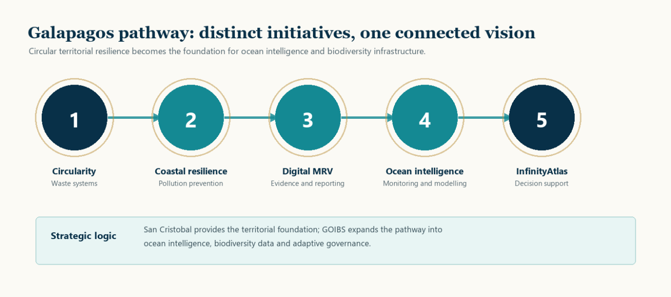
From field action to policy-relevant ocean intelligence.
InfinityGaia develops territory-based implementation models using public evidence, community engagement and finance-ready project architecture.
Governance
Adaptive decisions
Designed to translate knowledge into planning, investment logic, institutional coordination and long-term resilience pathways.
Pollution
Land–sea prevention
Designed to reduce land-based sources of marine pollution through circular waste systems, traceability and local coordination.
Evidence
Digital MRV
Designed to structure indicators, records and reporting tools so implementation can be measured, communicated and improved.
Biodiversity
Ocean signals
Intended to connect biodiversity and environmental observations with interoperable systems and decision-ready analysis.
What The Architecture Enables
The pathway is designed to translate practical implementation into evidence that can support institutions, communities, funders and scientific partners.
A proposed ocean-intelligence layer built on real territorial foundations.
GOIBS + InfinityAtlas
These initiatives are distinct but strategically connected. The first strengthens the operational and territorial foundations required to reduce pollution and improve island resilience. The second is designed to extend that foundation into an ocean-intelligence and biodiversity architecture capable of supporting adaptive governance, scientific collaboration and future replication. InfinityAtlas is being developed as the digital MRV and data-integration layer supporting that evolution.
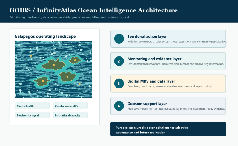
Conceptual illustration developed by InfinityGaia. It represents the proposed relationship between territorial action, environmental monitoring, digital MRV, interoperable data and decision support through the GOIBS and InfinityAtlas architecture; it does not depict deployed infrastructure.
Ocean Decade and DITTO Alignment
Ocean Decade framework
The United Nations Decade of Ocean Science for Sustainable Development (2021–2030) provides a global framework for co-designing and co-delivering the knowledge needed to inform decision-making and science-based solutions. Its vision is “the science we need for the ocean we want.”
InfinityGaia’s Galápagos pathway is designed around that progression: knowledge to action, action to evidence, and evidence to responsible governance and measurable implementation.
DITTO conceptual alignment
Digital Twins of the Ocean (DITTO) was established to advance a digital framework integrating marine data, modelling and simulation, artificial-intelligence algorithms and specialised tools for accessing, analysing and visualising ocean information.
GOIBS was submitted under Ocean Decade Call No. 11/2026 with DITTO selected as its proposed host programme, reflecting conceptual alignment with digital-twin approaches to ocean intelligence, biodiversity information and decision support.
Conceptual Alignment
1. Act
Advance territorial operations and pollution prevention
2. Measure
Develop MRV indicators, local data and evidence products
3. Integrate
Connect biodiversity observations with interoperable data systems
4. Decide
Support risk-informed, policy-relevant decisions
5. Scale
Adapt the architecture for island and ocean territories
Knowledge matters when it becomes responsible governance and measurable implementation.
Shared Ocean Vision
Galápagos can show how ocean solutions are designed, measured and
progressively scaled.
Together, circular systems, biodiversity protection, ethical data governance, digital MRV and ocean-climate resilience define InfinityGaia’s long-term vision for Galápagos.